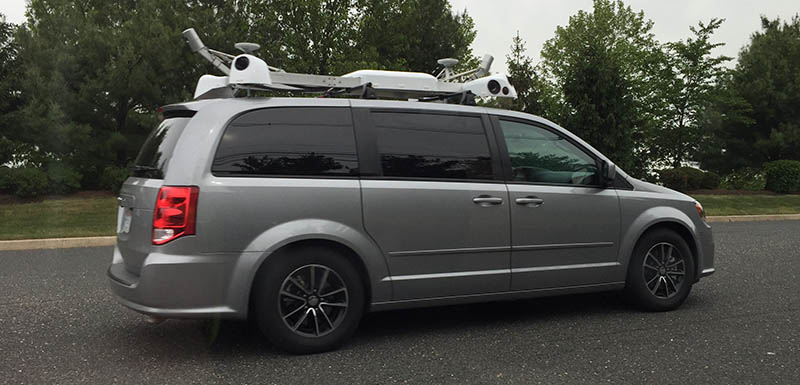
Apple has confirmed that it has been using a fleet of vehicles to collect street-level images for the “street view” feature in its Apple Maps apps. A support document published by the Cupertino firm notes that Apple will be blurring faces and license plates on the images.

Apple, via MacRumors:
“Apple is driving vehicles around the world to collect data which will be used to improve Apple Maps. Some of this data will be published in future Apple Maps updates. We are committed to protecting your privacy while collecting this data. For example, we will blur faces and license plates on collected images prior to publication.”
The document also lists where the vehicles will be driving in the United States, England, and Ireland from June 15 to June 30:
Ireland
Leinster
Dublin (Dublin City [Ashtown, Ballybough, Ballyfermot, Ballygall, Ballymun, Beaumont, Cabra, Chapelizod,Cherry Orchard, Clontarf, Coolock, Crumlin, Donaghmede, Drimnagh, Drumcondra, East Wall, Fairview, Finglas,Firhouse, Glasnevin, Inchicore, Irishtown, Kilbarrack, Kilmainham, Kilmore, Kimmage, Knocklyon, North Wall,Pembre, Phibsborough, Raheny, Rathfarnham, Rathgar, Rathmines, Ringsend, Sandymount, Santry,Templeogue, Terenure, The Liberties, Walkinstown, Whitehall], Dún Laoghaire–Rathdown, Fingal, South Dublin)
England
East of England
Essex (Brentwood, Epping Forest), Hertfordshire (Broxbourne, Dacorum, Hertsmere, St Albans, Three Rivers,Watford, Welwyn Hatfield)
Greater London
Barking and Dagenham, Barnet, Bexley, Brent, Bromley, Camden, City of London, City of Westminster,Croydon, Ealing, Enfield, Greenwich, Hackney, Hammersmith and Fulham, Haringey, Harrow, Havering,Hillingdon, Hounslow, Islington, Kensington and Chelsea, Kingston upon Thames, Lambeth, Lewisham,Merton, Newham, Redbridge, Richmond upon Thames, Southwark, Sutton, Tower Hamlets, Waltham Forest,Wandsworth
South East
Kent (Dartford, Sevenoaks), Surrey (Elmbridge, Epsom and Ewell, Spelthorne)
West Midlands
Birmingham (Sutton Coldfield, Perry Barr, Erdington, Ladywood, Hodge Hill, Yardley, Edgbaston, Hall Green, Selly Oak, Northfield), Dudley, Sandwell, Solihull, Staffordshire, Walsall, Warwickshire, Worcestershire
United States
Arizona
Pima (Tucson)
California
Alameda (Oakland), Los Angeles (Los Angeles)
Florida
Orange County (Orlando)
Georgia
Fulton (Atlanta)
Hawaii
Hawaii (Oahu)
Illinois
Cook (Chicago)
Massachusetts
Suffolk (Boston)
Michigan
Wayne (Detroit)
Missouri
St. Louis (St. Louis)
New York
New York (New York City)
Texas
Dallas (Dallas), Tarrant (Fort Worth)
Utah
Salt Lake (Salt Lake City)
Washington
King (Seattle)
Apple has been using Dodge Caravans equipped with LiDAR camera equipment on the roof to collect street-level imagery in the United States. The mapping vehicles have been spotted in at least a dozen states so far. (MacRumors has put together a handy little map they update as new sightings are reported. You can view it here.)
Apple’s street-level imagery program is all part of a larger shift by the company to bring such data in-house, reducing its reliance on outside firms, such as TomTom, which has been a mapping data provider for Apple Maps since it was launched.

